|
||||||||||
 |
 |
|||||
|
TOWNS & VILLAGES Balnarring & Surrounds Blairgowrie Dromana Flinders & Surrounds Frankston & Surrounds French Island Hastings & Surrounds Mornington & Surrounds Mount Eliza Mount Martha Red Hill & Surrounds Rosebud & Surrounds Rosebud West Rye & Surrounds Safety Beach & Hidden Harbour Sorrento & Portsea Tyabb & Surrounds ACCOMMODATION Bed & Breakfast Caravan & Holiday Parks Hotels & Motels Pets Welcome Self Contained & Other Booking Services ATTRACTIONS Antiques & Collectables Beaches Boat Hire & Jet Ski Hire Day Spas & Hot Springs Dolphin & Seal Swims Fishing Galleries Golf Historical Homes & Gardens Horse Riding Markets & Fairs Museums Tours Walks Parks & Wildlife Water Activities Wineries Winery Tours Other FOOD & DINING Cafe's Restaurants Healthy Food Fast Food ENTERTAINMENT Cinemas & Theatres Clubs Pubs Nightclubs Other SHOPPING Go to Shopping Index SERVICES Go to Business Services Index CHI Travel Insurance
TRAVEL SITES
|
Historical Facts - Mornington Peninsula
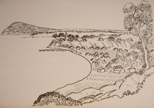
Collins first task was to look for a place to establish a settlement. Of most importance to him was 'possessing the advantages of fresh water, timber for building and soil for agricultural pursuits where on I can land my people'. He never found what he was looking for. Some would say later he did not try hard enough. A day after his arrival at Port Philip Bay, Collins set out with Captain Woodriff and landed at what is now called Chinamans Creek at Rosebud West. 'Here we found fresh water' Collins reported 'and enough for my purposes but the water was difficult to collect'. He also noted 'a soil of sand only'. Collins and Woodrif then crossed to the western side of Port Philip Bay to the Bellarine Peninsula where they 'found the soil somewhat better, but entirely destitute of that great essential, fresh water'. Collins had been instructed to unload the 2 ships without delay. Because of this he felt that he could not continue his exploration. On the 13th October 4 days after his arrival Collins and Captain Woodriff went ashore on the eastern side near Cameron's Bight where very good fresh water had been obtained by sinking six casks with perforations in their sides into the sand near the margin of the seashore. In the bay adjoining this he found about 5 level acres upon which he decided to land the people, stores and provisions. Located between two points or headlands known as the sisters, Sullivan bay was named after the British Undersecretary for War and the Colonies, John Sullivan. While the ships unloaded, Woodriff sent Lieutenant Tucky and a party which included George Harris, William Collins and William Gammon in the Calcutta's launch on a more detailed study of the area. They were to search for sites that might be more suitable for settlement than Sullivans bay. The party set out on 16th October and retuned 10 days later having traveled around Port Philip Bay. On this expedition Tuckey found two or three streams of water issuing from springs at Arthurs Seat. They also discovered drinking water at what is now called Kananook Creek near Frakston. At the north of the bay Tuckey noted a breal in the land which had the appearance of a river mouth but due to bad weather were unable to examine it. This of course was what we now know as the Yarra River. They continued on around the bay. Tuckey wrote about the land near present day Geelong which was 'extremely rich' and described Corio Bay as 'a perfectly secure and commodious harbour'. He also said that 'by uniting several pools of fresh water into a large shaded reservoir of a good depth a constant supply of water may be retained.' He claimed that 'no spot will answer to the raising of wheat or any other grain that requires moisture.' Collins must have been distressed by the reports gloomy content. He wrote that Sullivan Bay involved a choice of difficulty and that he felt his party could not be better placed. The lack of relics means that our knowledge of the layout of the site depends mainly on three sketches made by George harris. These show that surgeon's tents were located nearby the northwest corner of Sullivan Bay on flat land close to the beach. The amrines encamped on flat land halfway between the sisters, protecting the stores located closer to the Eastern sister. The Lieutenant Governor and the civil officers including the chaplin, surveyor and mineralogist occupied land on the eastern sister and on it's western slope, as did Mrs Powers tent. The huts of the free settlers were located to the south east of the eastern sister behind the watering place in Camerons Bight. The landing place was on the beach near the eastern sister. The free settlers on the northeast side of the camp were given parcels of land for gardening. Most men spent each day clearing the land, sowing seeds bought from Rio de Janeiro and tending their vegetable gardens. The settlers wives also worked in the gardens and looked after children. Sources of information include 'No Place for a Colony' by Richard Cotter, 'Mornington iin the wake of Flinders' by Leslie Moorhead, The logs of the Lady Nelson, 'A Voyage to Establish a Colony at Port Philip in Bass's Strait On the South Coast of New South Wales, in His Majesty's Ship Calcutta, in the Years 1802-3-4' by James Hingston Tuckey, ADB and other sources |
| CONTACT US | ADVERTISE WITH US | LIST YOUR EVENT | ABOUT THIS SITE | TERMS & CONDITIONS | PRIVACY POLICY | SITEMAP | |
DISCLAIMER | |||||||